From the East (Winston Salem) - via the Blue Ridge Parkway
- Take 40 West to Exit 55.
- Turn right at the end of the ramp.
- At the stop light turn left onto highway 70.
- Go 0.9 of a mile and turn right onto the Blue Ridge Parkway.
- Head North on the BRPW, there will be a sign.
- Go about 6 miles on the parkway.
- Just past mile marker 376, you will come to Bull Gap.
- Turn left at Bull gap.
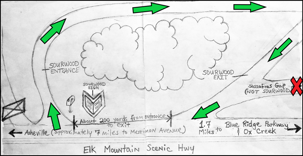
- Go 0.2 of a mile and turn left onto Elk Mountain Scenic Highway.
- You should still be going uphill at this point.
- Travel 1.7 miles on Elk Mountain Scenic Highway and Sourwood will be on your right.
From the East (Winston Salem) - via Asheville
- Take 40 West to 240 west as you approach Asheville.
- Take exit 5A (Merrimon Avenue and hwy 25).
- At the end of the ramp turn right onto Merrimon Ave., 25 North and go for 2.1 miles.
- Turn right onto Beaverdam Road.
- Go .6 of a mile on Beaverdam Road.
- Turn left onto Elk Mountain Scenic Highway and go 5.5 miles.
- This will be a very long and windy 5.5 miles, so use your odometer.
- Sourwood will be on your left.
From the West (Knoxville)
- Take 40 east towards Asheville to 240 east.
- Take exit 5A (Merrimon Avenue, highway 25).
- At the end of the ramp turn right onto Merrimon Ave., 25 North and go for 2.1 miles.
- Turn right onto Beaverdam Road.
- Go .6 of a mile on Beaverdam Road.
- Turn left onto Elk Mountain Scenic Highway and go 5.5 miles.
- This will be a very long and windy 5.5 miles, so use your odometer.
- Sourwood will be on your left.
From the North (Johnson City)
- Take 26 East (future) out of Johnson City towards Asheville.
- Take the North Asheville Exit. (This will be the exit after New Stock Road.)
- Turn right at the stop light onto 25 South. (aka Merrimon Avenue) Stay on 25 South.
- You will go through another stop light and then pass a residential lake, Beaver Lake.
- At the first traffic light after you pass the lake, turn left onto Beaverdam Road.
- Go .6 of a mile on Beaverdam, then turn left onto Elk Mountain Scenic Highway.
- Once on Elk Mountain Scenic Highway, go 5.5 miles.
- This will be a very long and windy 5.5 miles, so use your odometer.
- After the 5.5 miles the sign for Sourwood will be on your left.
From the South (Spartanburg)
- Take 26 West towards Asheville.
- As you approach Asheville, take 240 east.
- Take exit 5A (Merrimon Avenue, highway 25).
- At the end of the ramp turn right onto Merrimon Ave., 25 North and go for 2.1 miles.
- Turn right onto Beaverdam Road.
- Go .6 of a mile on Beaverdam Road.
- Turn left onto Elk Mountain Scenic Highway and go 5.5 miles.
- This will be a very long and windy 5.5 miles, so use your odometer.
- Sourwood will be on your left.
From the Charlotte Airport
- Take 85 South towards Gastonia.
- Take Highway 74 west at Kings Mountain heading towards Shelby.
- Continue on 74 west to 26 west.
- Take 26 West towards Asheville.
- As you approach Asheville, take 240 east.
- Take exit 5A (Merrimon Avenue, highway 25).
- At the end of the ramp turn right onto Merrimon Ave., 25 North and go for 2.1 miles.
- Turn right onto Beaverdam Road.
- Go .6 of a mile on Beaverdam Road.
- Turn left onto Elk Mountain Scenic Highway and go 5.5 miles.
- This will be a very long and windy 5.5 miles, so use your odometer.
- Sourwood will be on your left.
From the Asheville Airport
- Take 26 West towards Asheville.
- As you approach Asheville, take 240 east.
- Take exit 5A (Merrimon Avenue, highway 25).
- At the end of the ramp turn right onto Merrimon Ave., 25 North and go for 2.1 miles.
- Turn right onto Beaverdam Road.
- Go .6 of a mile on Beaverdam Road.
- Turn left onto Elk Mountain Scenic Highway and go 5.5 miles.
- This will be a very long and windy 5.5 miles, so use your odometer.
- Sourwood will be on your left.